WALK ROUTES
Further information:
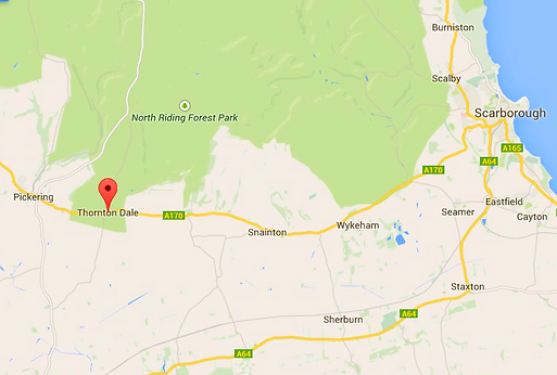
Thornton-le-Dale (also called Thornton Dale) is a village in the Ryedale district of North Yorkshire, about three miles east of Pickering on the edge of the North York Moors National Park, Close to Dalby Forest which is divided by a number of valleys creating a 'Rigg and Dale' landscape whilst to the north the forest sits on the upland plateau.
.
Short Walk:
7.5 miles Leaders: Andrea, John (Easy)
From Thornton le Dale to Dalby Forest by tracks,
leaving the forest by road for a short distance (slight climb) then across fields and farms (may be muddy in parts) and back to Thornton Le Dale.
Good views and plenty of wildlife to be seen
Medium Walk:
12 miles Leaders: Julie, Lorraine (Moderate)
Same route into Dalby Forest, but leaving the forest
on a short climb to open ground, continuing with a short steep climb to fields and farms, past a pub on to a descent through a grass valley.
Crossing the Pickering to Grosmont railway (crossing) then following the track for a mile crossing to the other side (crossing) then a short climb to fields which lead to a long flat track through a wooded dale which is deeply rutted and may be very muddy.
Across fields and a few stiles to the road back into Thornton Le Dale
Long Walk:
15 Miles Leader: Dave Fothergill (Moderate)
Into Dalby Forest as above then through the forest, following the climbing Sandy Dale track before reaching open ground and returning the same route (passing a pub!!) as the medium walk.
APRIL Walk - Thornton-le-dale
Organised by Julie Cade
Sunday April 12th 2015
Coach to drop off at Thornton Le Dale car park .
Toilets available at car park.
Plenty of cafes and two pubs, New Inn and Buck Inn
Did you know.....
A thatched cottage in the village has appeared on countless calendars and chocolate boxes over the years
Thornton-le-dale, North Yorkshire


© 2014PontefractWalkingClub. Proudly created with Wix.com
